

Product on sale
Rhode Island and the Providence Area Wall Map on Sale
20 people are viewing this right now
4 products sold in last 12 hours
Selling fast! Over 19 people have this in their carts
- Estimated Delivery : Up to 4 business days
- Free Shipping & Returns : On all orders over $200
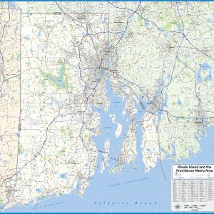
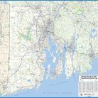
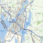
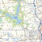
Our Rhode Island and the Providence Metro Area wall map shows a 50 mile by 50 mile area including all of the State of Rhode Island as well as nearby parts of Massachusetts and Connecticut. The communities of Providence, Pawtucket, Cranston, Woonsocket, Attleboro, Taunton, Fall River, New Bedford, Newport, Westerly, and Warwick are shown, among others. Features shown include cities, towns, counties, highways and major and secondary roads, zip codes, and major points of interest. Note: due to the vast extent of this map, local street names are not shown.
This map comes in a variety of sizes and finishing options. It is shipped rolled in a sturdy cardboard tube.
| Size | 39×36, 46×42, 52×48, 61×56 |
|---|---|
| Material | Paper, Laminated, Laminated with Hanging Rails |