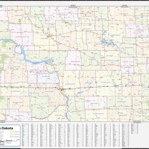
Wall map of North Dakota, showing counties, towns, cities, villages, major roads and highways. Includes community index. This map comes in a variety of sizes and finishing options. It is shipped rolled in a sturdy cardboard tube.
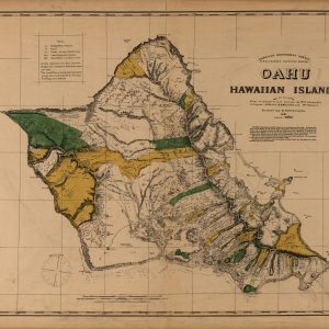
This beautiful antique map reproduction is printed on heavy acid-free stock with fade proof inks and is excellent for framing. Relief on the map is shown using hachures and spot heights. Copyright Hawaiian Government Survey, 1881 Size: 36 × 29
Bathymetry and currents Physical Terrain Ocean Relief Beautifully illustrated with subtle earth tone hues, the detail is highly legible with country borders clearly defined. In classic Atlas style, this map can be used for general reference, to track current events, or as a piece of art.Decorators will find the color scheme works beautifully with most…
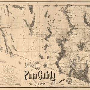
This beautiful antique map reproduction is printed on heavy acid-free stock with fade proof inks and is excellent for framing. Copyright George J. Roskruge, 1893 Size: 50 × 27
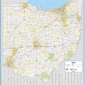
Wall map of Ohio, showing counties, towns, cities, villages, major roads and highways. Includes community index. This map comes in a variety of sizes and finishing options. It is shipped rolled in a sturdy cardboard tube.
Our Oklahoma City Metro Area wall map shows the area within 25 – 30 miles of downtown Oklahoma City, including the communities of Shawnee, Bethany, Chandler, Chickasha, Choctow, Del City, Edmond, El Reno, Harrah, Jones, McLoud, Midwest City, Moore, Mustang, Newcastle, Nichols Hills, Nicoma Park, Noble, Norman, Piedmont, Purcell, Spencer, Tuttle, The Village, Warr Acres,…
Oklahoma lies where the sweeping prairies of the Great Plains meet the western shoulder of the Ozark Mountains. This wall map illustrates The Sooner State’s array of country roads and recreation opportunities. If outdoor adventure and recreation is your thing, this is the map for you. This map is loaded with points of interest from…
Wall map of Oklahoma, showing counties, towns, cities, villages, major roads and highways. Includes community index. This map comes in a variety of sizes and finishing options. It is shipped rolled in a sturdy cardboard tube.
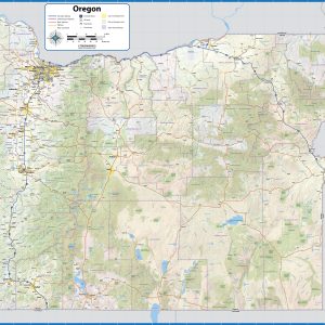
With its rugged but peaceful Pacific Coast and inland features like Crater Lake and myriad mountain peaks and hidden waterfalls, Oregon is a favorite destination for travelers across the American West. This wall map illustrates the public lands and recreation hotspots across The Beaver State. If outdoor adventure and recreation is your thing, this is…
Wall map of Oregon showing counties, towns, cities, villages, major roads and highways. Includes community index. This map comes in a variety of sizes and finishing options. It is shipped rolled in a sturdy cardboard tube.
This beautiful antique map reproduction is printed on heavy acid-free stock with fade proof inks and is excellent for framing. Copyright J.J. Stoner, 1879 Size: 35 × 22
This beautiful antique map reproduction is printed on heavy acid-free stock with fade proof inks and is excellent for framing. This map is indexed for points of interest. Copyright Henry Wellge & Co., 1887 Size: 32 × 21
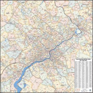
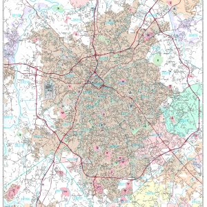
Our laminated Philadelphia Metro Area ZIP Code Map highlights zip code areas within the metro Philadelphia area. The perfect tool for visualizing the big picture for the entire Philadelphia Metro area, each zip code is colorized and labeled for quick identification. The map also shows counties, communities, and major roads. An index of zip codes…
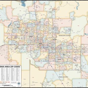
Our Phoenix Metro Area ZIP Code Map highlights zip code areas within a 70 mile wide by 60 mile high region of central Arizona. The perfect tool for visualizing the big picture for the entire Phoenix Metro area, each zip code is colorized and labeled for quick identification. The map also shows counties, communities, and…
Save money on our full line of wall maps from one of the industry leaders in wall maps. These always up to date, eye catching wall maps come in a variety of sizes and finishing options sure to meet your specific mapping needs. Features include: Interstate Us State Highways 5-Digit ZIP Codes County Names and…
This beautiful antique map reproduction is printed on heavy acid-free stock with fade proof inks and is excellent for framing. This map features township and county lines and shows drainages, cities and towns, and the named railroad network. Copyright H. H. Lloyd & Co., 1871 Size: 27 × 37