Product on sale
Oklahoma City Metro Area Wall Map Cheap
29 people are viewing this right now
5 products sold in last 10 hours
Selling fast! Over 16 people have this in their carts
- Estimated Delivery : Up to 4 business days
- Free Shipping & Returns : On all orders over $200
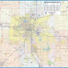
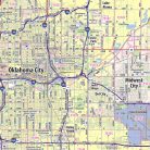
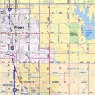
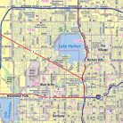
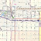
Our Oklahoma City Metro Area wall map shows the area within 25 – 30 miles of downtown Oklahoma City, including the communities of Shawnee, Bethany, Chandler, Chickasha, Choctow, Del City, Edmond, El Reno, Harrah, Jones, McLoud, Midwest City, Moore, Mustang, Newcastle, Nichols Hills, Nicoma Park, Noble, Norman, Piedmont, Purcell, Spencer, Tuttle, The Village, Warr Acres, and Yukon, among others. Features shown include cities, towns, counties, highways and major and secondary roads, zip codes, and major points of interest. Note: due to the vast extent of this map, local street names are not shown.
This map comes in a variety of sizes and finishing options. It is shipped rolled in a sturdy cardboard tube.
| Size | 43×36, 50×42, 57×48, 67×56 |
|---|---|
| Material | Paper, Laminated, Laminated with Hanging Rails |