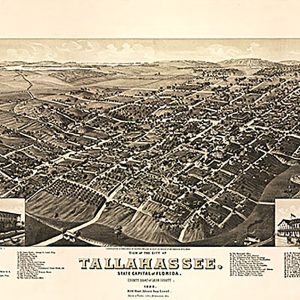
View of the city of Tallahassee, county seat of Leon county, 1885 This beautiful antique map reproduction is printed on heavy acid-free stock with fade proof inks and is excellent for framing. 23 W x 16 H
View of the University of Virginia, Charlottesville & Monticello…, 1856This beautiful antique map reproduction is printed on heavy acid-free stock with fade proof inks and is excellent for framing. 24 W x 18 H
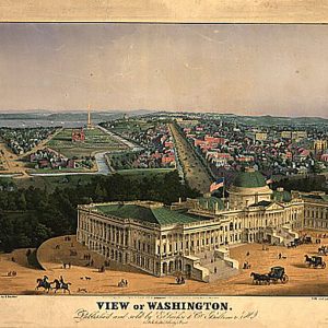
View of Washington by E. Sachse & Co., 1852This beautiful antique map reproduction is printed on heavy acid-free stock with fade proof inks and is excellent for framing. 27 W x 19 H
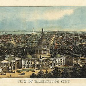
View of Washington City by E. Sachse & Co., 1871This beautiful antique map reproduction is printed on heavy acid-free stock with fade proof inks and is excellent for framing. 25 W x 18 H
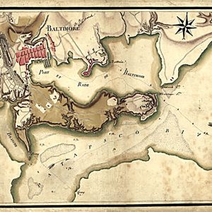
Ville, port, et rade de Baltimore dans le Maryland.Berthier, Louis-Alexandre, 1753-1815. CREATED PUBLISHED 1781 This beautiful antique map reproduction is printed on heavy acid-free stock with fade proof inks and is excellent for framingVille, port, et rade de Baltimore dans le Maryland.Berthier, Louis-Alexandre, 1753-1815. CREATED PUBLISHED 1781 This beautiful antique map reproduction is printed on…
Add the touch of South Africa to your workplace for 2023 with this African Wildlife 2023 Desk Calendar. .: One size: 10 x 5 (25cm x 12.5cm).: Paper thickness: 270 gsm.: Spiral bound at the top
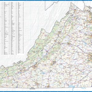
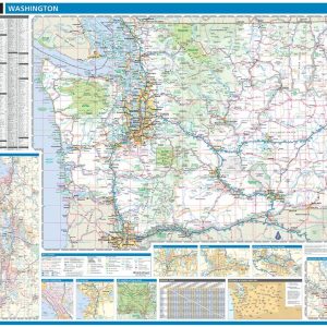
Laminated with Hanging Rails 60 W x 46 H Index of Counties and Cities Fully Indexed Counties, Cities, Mileage Chart Inset Maps of All Major Cities Free Shipping! This map is rolled and shipped in a sturdy cardboard tube.
Wall map of Virginia, showing counties, towns, cities, villages, major roads and highways. A community index is included. This map comes in a variety of sizes and finishing options. It is shipped rolled in a sturdy cardboard tube.
This colorful, easy-to-read state map of Virginia identifies all major thoroughfares, secondary roads, freeway interchanges, rest areas, distance markers, landmarks, recreational areas, and more. Shaded relief on the state map provides a three-dimensional sense of Virginia s topography. Detailed city inset maps of Charlottesville, Lynchburg, Norfolk Virginia Beach, Petersburg, Richmond, Roanoke, and Williamsburg are based…
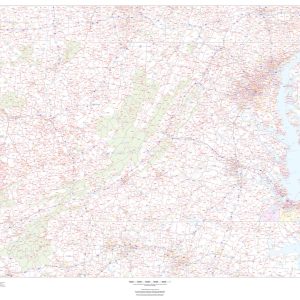
This map of Virginia shows ZIP codes overlaid on a road map. Base map features include county boundaries, major road network features, and state and national parks and conservation areas. This map is rolled and shipped in a sturdy cardboard tube.
Virginia, discovered and discribed by Captayn John Smith, 1606; graven by William HoleThis beautiful antique map reproduction is printed on heavy acid-free stock with fade proof inks and is excellent for framing. 25 W x 20 H
Express your South African roots with this Voetsek Vanity Plate. Each plate is 100% made with robust aluminum material and comes with pre-drilled holes for hassle-free installation. Measuring in at 12 x 6 , it is the perfect size to decorate any vehicle or wall as a stylish statement piece. .: Material: 100% aluminum.: One…
As family toffee makers for over 100 years Walkers Nonsuch have used their expertise to create Walker s Treacle Toffees, an irresistible treat made with the finest ingredients, including whole milk, butter and black treacle. Individually wrapped pieces. Gluten Free and suitable for vegetarians.
Laminated with Hanging Rails 60 W x 46 H Index of Counties and Cities Fully Indexed Counties, Cities, Mileage Chart Inset Maps of All Major Cities Free Shipping!