Giraffe mother and baby art print for kid s room and nursery decor. Calm & colorful watercolor A4 nursery wall art or a baby boy or girl. A4 Print. All prints use Epson Ultra Chrome archival inks, on 230gsm smooth matte paper. Hand painted by Pudding & Pickles in their Cape Town studio. Please note that…
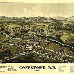
Goffstown, New Hampshire by George E. Norris, 1887.This beautiful antique map reproduction is printed on heavy acid-free stock with fade proof inks and is excellent for framing. 23 W x 18 H
Thanks to this delectable, fruity topping, your vanilla ice cream, cheesecake and even meringues will never be the same again. Featuring the tantalizing taste and flavor of tangy granadilla, this scrumptious delight is a delicious choice. Versatile and irresistibly tangy, this granadilla delight adds the perfect finishing touch to your after dinner treats. Simply delicious as a…
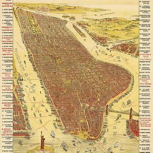
Birds-eye view map on a poster for the play, The Pulse of New York , 1891.This beautiful antique map reproduction is printed on heavy acid-free stock with fade proof inks and is excellent for framing. 20 W x 30 H
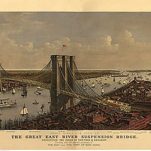
Grand Birds Eye View of the Great East River Suspension (Brooklyn) Bridge by Currier & Ives, 1885.This beautiful antique map reproduction is printed on heavy acid-free stock with fade proof inks and is excellent for framing. 27 W x 19 H
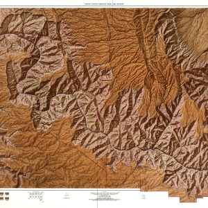
This beautiful antique map reproduction of the Grand Canyon and the mighty Colorado River is printed on heavy acid-free stock with fade proof inks. It is excellent for framing. Copyright U.S.G.S., 1972 Size: 50 × 31
Our Grand Rapids Metro Area wall map shows the area within 30 miles of downtown Grand Rapids , including the communities of Kentwood, Wyoming, Northview, Rockford, Muskegon, Grand Haven, Holland, Douglas, and Hastings, among others. All of Kent County and Ottawa County are shown, as well as adjacent areas of nearby counties. Features shown include…
Grand View of Chicago, 1893This beautiful antique map reproduction is printed on heavy acid-free stock with fade proof inks and is excellent for framing. 34 W x 23 H
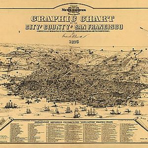
Graphic chart of the city and county of San Francisco, 1875This beautiful antique map reproduction is printed on heavy acid-free stock with fade proof inks and is excellent for framing. 30 W x 20 H
Gray s aero view of the port of New York, 1913.This beautiful antique map reproduction is printed on heavy acid-free stock with fade proof inks and is excellent for framing. 16 W x 25 H
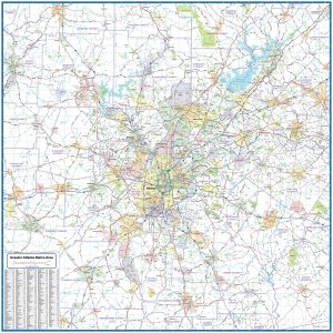
This extremely functional wall map of the Atlanta Regional area, showing locations within 40 miles of downtown Atlanta includes counties, towns, cities, major roads and highways, and major points of interest. Use it for planning your delivery routes, sales zones or any other business needs. This map is both functional and decorative. Sized perfectly, this will…
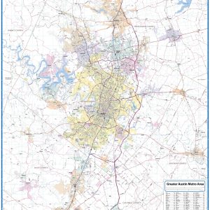
This wall map of the Austin metro area shows locations within 25 miles of downtown Austin, including Travis County, and parts of Hays, Williamson and Bastrop Counties. Communities included are Georgetown, Leander, Cedar Park, Round Rock, Pflugerville, Lago Vista, Lakeway, Bee Cave, Kyle, San Marcos and Lockhart, among others. Features shown include cities, towns, major…
Our Greater Boise Metro Area wall map shows a 50 mile wide by 35 mile high area centered on Boise, Idaho. It includes parts of Ada County and Jefferson County. It shows the communities of Boise, Garden City, Meridian, Nampa, Caldwell, and Eagle, among others. Features shown include cities, towns, counties, highways and major and…
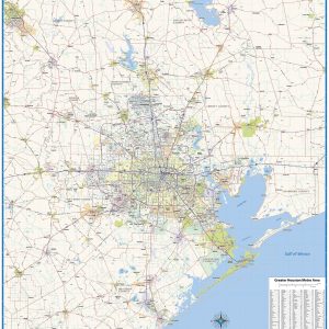
This wall map of the greater Houston includes the coverage area north to Huntsville and Lake Livingston, south to Freeport, west to Sealy and east to Winnie. Features shown include cities, towns, major roads and highways, zip codes, and major points of interest. An index of community names is included. This map is rolled and…