Show your neighbors and the world that Made with lightweight yet highly durable poly poplin-canvas fabric, these banners feel premium to the touch and will oversee your home for years on end. Specifications 100% Poly poplin-canvas fabric Two sizes (12 × 18 and 24.5 × 32 ) Same design printed on both sides, flag flipped…
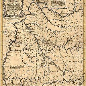
Kentucke [sic] by John Filson, 1784This beautiful antique map reproduction is printed on heavy acid-free stock with fade proof inks and is excellent for framing. 21 W x 24 H
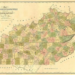
Kentucky & Tennessee by David H. Burr, 1839This beautiful antique map reproduction is printed on heavy acid-free stock with fade proof inks and is excellent for framing. 35 W x 26 H
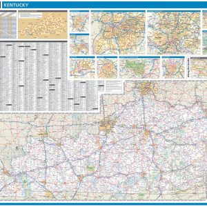
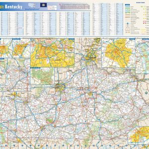
Laminated with Hanging Rails 60 W x 46 H Index of Counties and Cities Fully Indexed Counties, Cities, Mileage Chart Inset Maps of All Major Cities Free Shipping! This map is rolled and shipped in a sturdy cardboard tube.
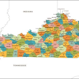
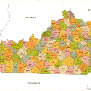
This map has been created and designed for reference or business use. Clear and clean colors & fonts matched with cartographic research makes this map of Kentucky Counties Map easily readable and useful. The map shows the 120 counties of Kentucky and their borders across the Bluegrass State. This map is rolled and shipped in…
This colorful, easy-to-read state map of Kentucky identifies all major thoroughfares, secondary roads, freeway interchanges, rest areas, distance markers, landmarks, recreational areas, and more. Shaded relief on the state map provides a three-dimensional sense of Kentucky s topography. Detailed city inset maps of Bowling Green, Frankfort, Lexington, Louisville, and Owensboro are based on the latest…
Laminated wall map of Kentucky, showing counties, towns, cities, villages, major roads and highways. A community index is included. This map comes in a variety of sizes and finishing options. It is shipped rolled in a sturdy cardboard tube.
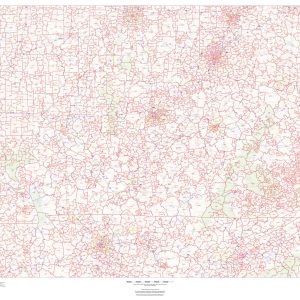
This map of Kentucky shows ZIP codes overlaid on a road map. Base map features include municipality and county boundaries, major road network features, and state and national parks and conservation areas. This map is rolled and shipped in a sturdy cardboard tube.
This map has been created and designed for business or reference use. Clear and clean colors & fonts matched with cartographic research makes this Kentucky Zip Code Map with Counties easily readable and useful. The map shows the 120 counties of Kentucky and the borders of the 761 zip codes across the Bluegrass State. This…
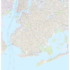
This map of Kings County, New York shows detailed street level information including extensive street labeling. Ideal for planning of deliveries, home services, sales territories, real estate and much more. Base map features include all roads with major roads and highways labelled; neighborhood names; railways; high level land use such as parks and recreation areas,…
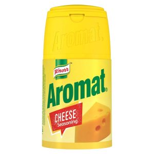
Use this savoury cheese-flavoured seasoning to enhance the flavour of your favourite recipes. This traditional seasoning is a firm favourite among many South Africans.
Bring out the best in veggies by roasting them with our Knorr Roasted Vegetable Bake – a rich, creamy sauce flavoured with herbs plus a dash of garlic.
Enjoy the delicious, home-style goodness made with real chicken. Enjoy every spoonful of Noodle Soup with Knorr s Chicken Noodle Soup. This is easy to prepare and a perfect companion for your favourite fried dishes. Classic Chicken Noodle Soup is developed from natural ingredients to bring about the right chicken flavour to your yummy noodle…
Simply add boiling water to create a deliciously smooth and creamy instant white sauce that is perfect in pasta dishes and bakes. This white sauce made with milk, flour and butter allows for quick and easy preparation. Make your everyday meals just as special as your special occasions thanks to this convenient and tasty sauce….